Introduction to Finding and Using Historical Maps
Online Mapping Tools
Google Earth Pro (Desktop)
Google Earth Pro is an excellent free mapping tool. To fully utilize its features, download the software onto your computer. Two of the most useful features for genealogists are the ability to see global changes over decades with the help of historic imagery and the ability to import a historic map file and overlay it on the modern map. Many of the websites listed throughout this guide have maps that can be downloaded and then added to Google Earth Pro.
Supplemental Reading About Using Google Earth Pro for Genealogy Research
Google Earth for Genealogy, Part 1: Putting Your Ancestors on the Map by NYG&B
Google Earth for Genealogy, Part 2: Adding Historical Maps & Data by NYG&B
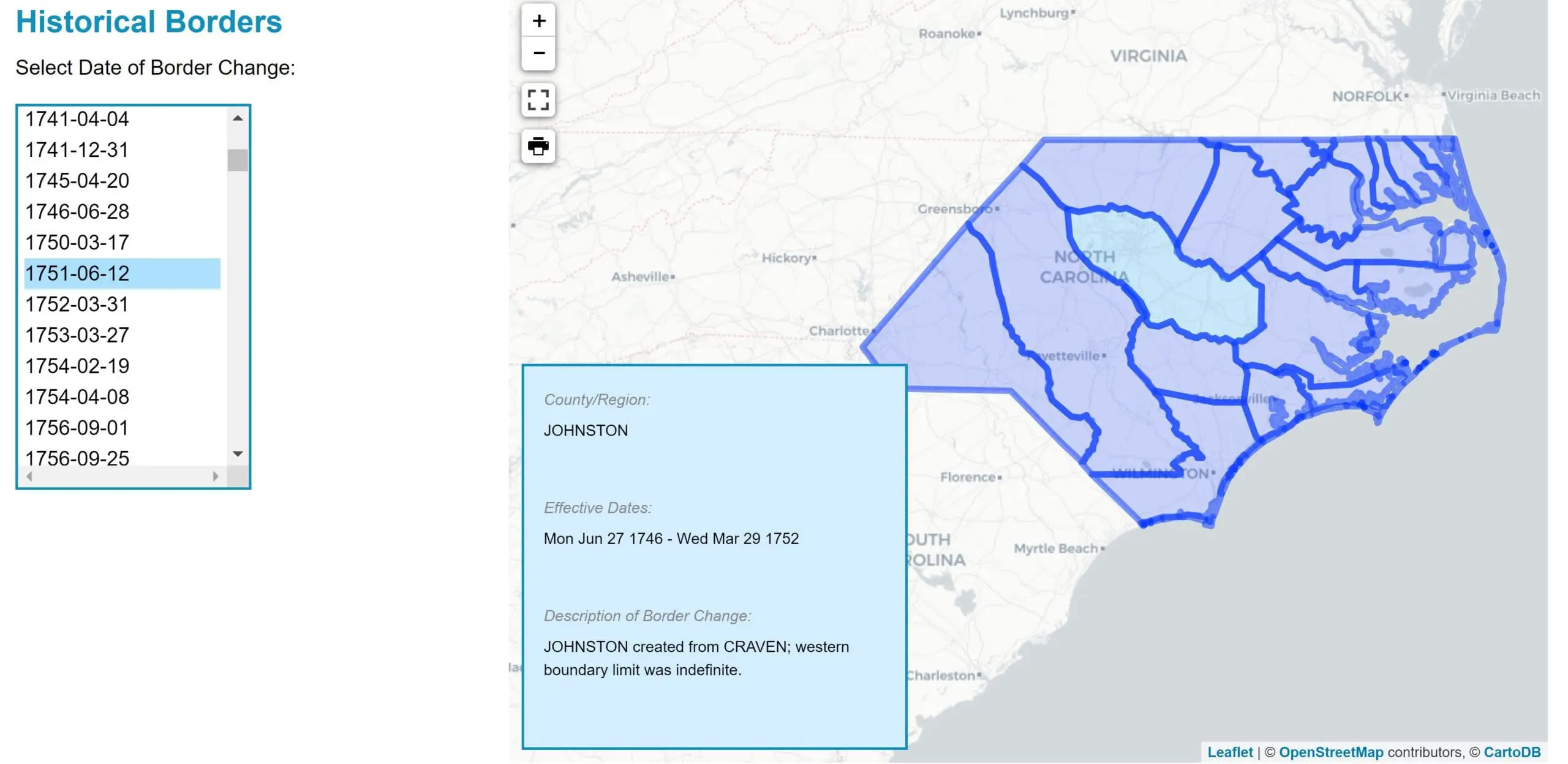
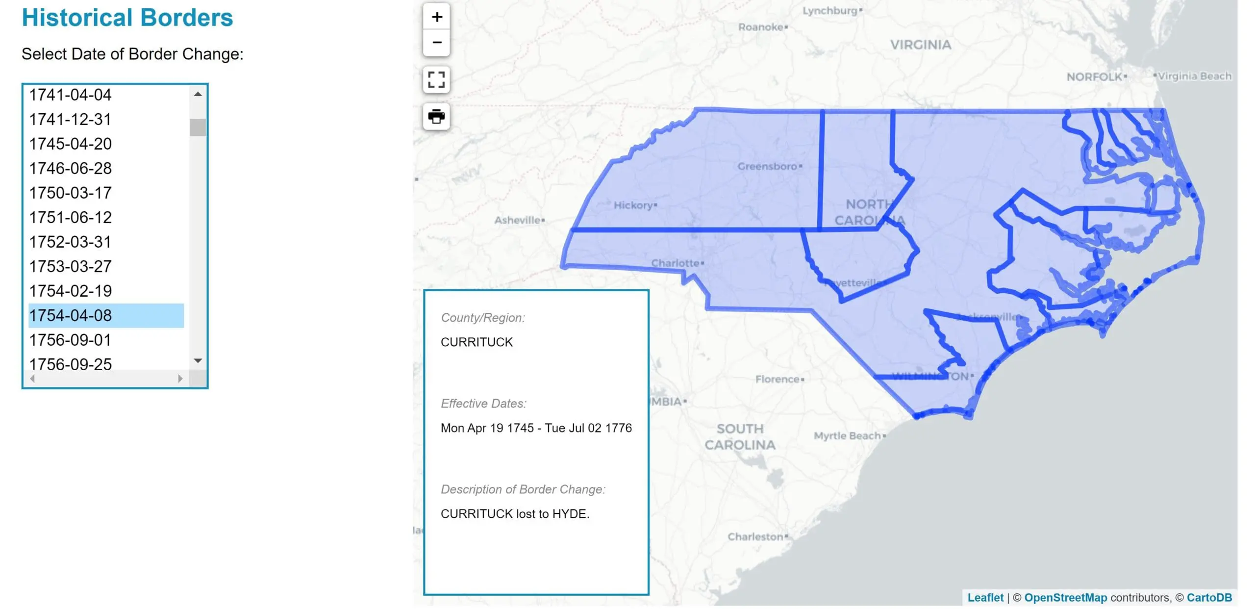
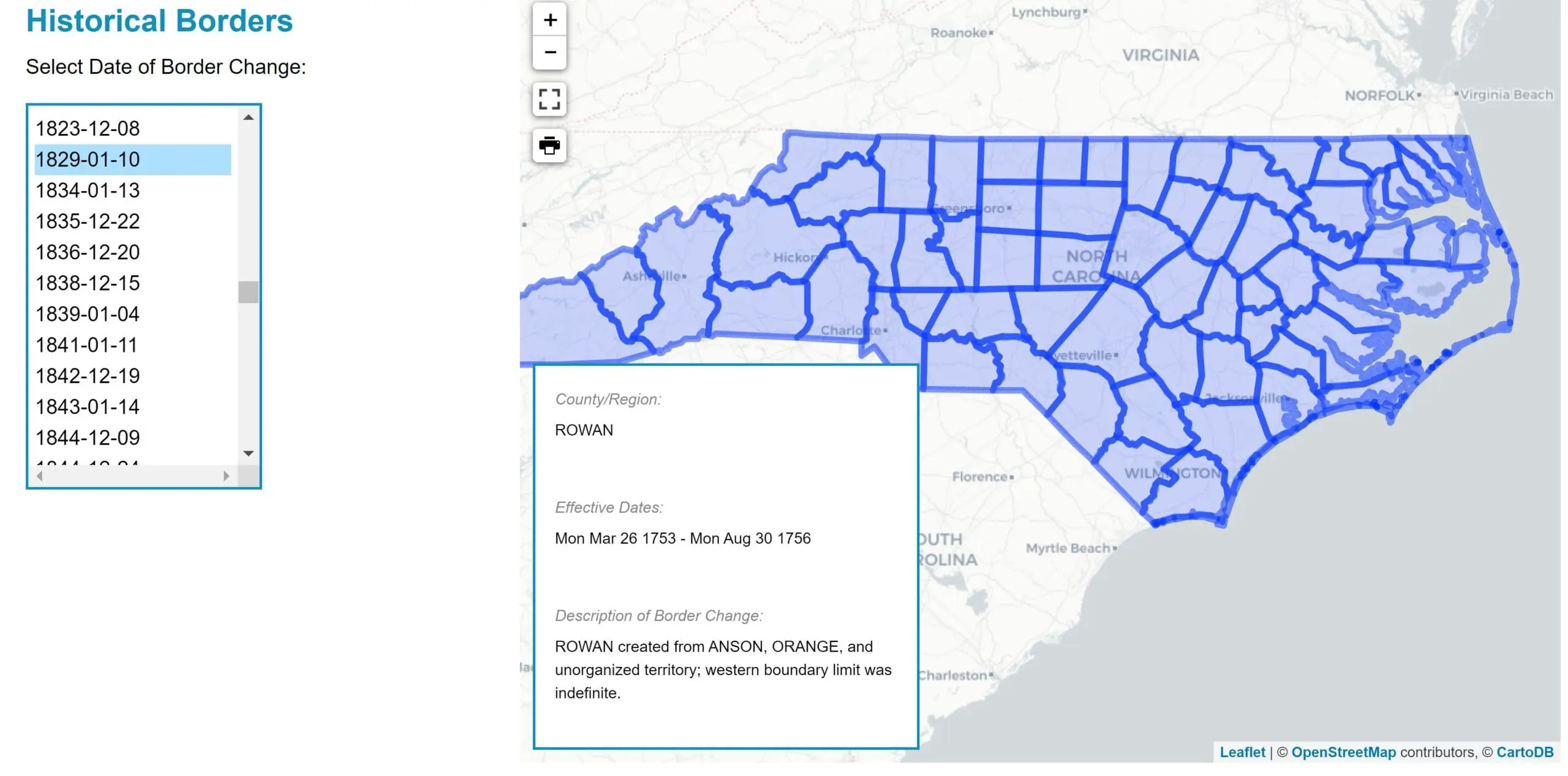
Newberry Atlas of Historical County Boundaries
This web-based atlas, produced by the Newberry Library, is a great resource for exploring changing county boundaries in all 50 states. It is a digital historical research and reference tool available for free public use.
“The Atlas presents in maps and text complete data about the creation and all subsequent changes (dated to the day) in the size, shape, and location of every county in the fifty United States and the District of Columbia. It also includes non-county areas, unsuccessful authorizations for new counties, changes in county names and organization, and the temporary attachments of non-county areas and unorganized counties to fully functioning counties. The principal sources for these data are the most authoritative available: the session laws of the colonies, territories, and states that created and changed the counties.”
This atlas is as comprehensive as possible covering both an expansive amount of time, starting in the 1600s and ending in the 2000s, and the complete geographic areas of all 50 states and the District of Columbia.
As a genealogist, it is vital to know which jurisdiction you should be researching. This valuable resource can help you determine those jurisdictions as you discover when counties were created and boundaries changed. The atlas can also provide additional historical context regarding the locality of your research.
Maps can be downloaded as a .kmz file and loaded into Google Earth providing a way to view historic boundaries on a modern map.
Lorem ipsum dolor sit amet, consectetur adipiscing elit, sed do eiusmod tempor incididunt ut labore et dolore magna aliqua. Ut enim ad minim veniam, quis nostrud exercitation ullamco laboris nisi ut aliquip ex ea commodo consequat.
Website: Newberry Atlas of Historical County Boundaries
USGS Historical Topographic Maps
The United States Geological Survey has been mapping the nation’s topography for nearly 150 years. Melinda Kashuba defines a topographical map as one that “describes physical features on the surface of the earth,” such as elevation changes, rivers, coastlines and even man-made features like railroads and canals. Users select maps from the National Map Download Client. This covers the entire USA with all editions going back in time. The TopoView interface also provides GeoTIFF, JPG, and KMZ versions making it possible to download maps and import them into Google Earth Pro.

Website: Historical US Geological Survey Topographic Maps
Supplemental Reading about using topographic maps for genealogy research
Using Maps for Genealogy Research, Part 4: Topographical Maps, and County Maps and Atlases by New York Public Library
How can topographic maps be useful in genealogical research? by USGS
Using Maps in Genealogy by USGS
Sanborn & Fire Insurance Maps
Sanborn Fire Insurance Maps are a valuable resource for your genealogy research. From 1867 to 1977, the Sanborn® Map Company produced large-scale color maps of commercial and industrial districts of thousands of North American towns to assist fire insurance companies in setting their rates. These are detailed maps of city neighborhoods that represents each built structure in those districts. These maps help show the growth of towns and cities and include a significant amount of detail regarding the types of buildings, materials used, width of streets, and much more.
If you already have a known address for an ancestor’s residence, you can discover exact details about their neighborhood and add rich historical context about their lives and geographic surroundings from the information recorded on these maps.
The North Carolina Collection at UNC-Chapel Hill holds the most comprehensive collection of Sanborn® maps in North Carolina. The holdings range in date from the 1880s to the 1950s and cover more than 150 cities and towns across the state. North Carolina Maps features online all of the North Carolina Collection’s Sanborn® maps produced through 1922. Maps published after that date will remain available for use on microfilm in the North Carolina Collection reading room.


Websites to Access North Carolina Sanborn Fire Insurance Maps
Library of Congress North Carolina Sanborn Maps
North Carolina Maps Digital Sanborn Maps
Supplemental Reading about using Sanborn Fire Insurance Maps for genealogy research
How to Use Sanborn Fire Insurance Maps for Family History by Lisa Louise Cook
Sanborn Fire Insurance Maps Now Online by the Library of Congress
How to Use Online Sanborn Maps for Genealogy by Family Tree Magazine
How to Use Fire Insurance Maps for Family History Research by Legacy Tree Genealogists
Geographic Names Information System (GNIS)
While this website does not include visual maps, it is a must-have when viewing historical maps or researching historical locations. If you happen upon a historical location that you cannot find on a current map, head straight to this database!
The GNIS was created by multiple U.S. government agencies with the purpose of maintaining uniform geographic name usage for the federal government. You will find both modern and historic names to help you discover the exact location using both topographic elements and man-made features. “The Geographic Names Information System (GNIS) actively seeks names of features that no longer exist. The term “historical” as used in the GNIS specifically means that the feature no longer exists on the landscape. An abandoned ghost town, for example, still exists so it is not historical. Historical features have no reference to age, size, condition, extent of habitation, type of use, or any other factor… There are more than 100,000 historical entries in the database. To search for them, type the word “historical” (along with other name words if desired) in the name field.”
Website: U.S. Board on Geographic Names
RandyMajors.com Research Hub
The RandyMajors.com Research Hub is a series of mapping and search tools that utilize Google Maps and historical data. You can view maps with overlays of the townships limits, city boundaries, area codes, counties, and more.
One particularly useful tool is the Historical U.S. Counties Auto-Checker Chrome extension. The auto-checker extension works while searching on Ancestry or FamilySearch. It automatically checks that the county existed in the year you are searching, checks for valid places, warns of boundary changes, and links to historical county lines on Google Maps for the place and years you are searching.
Learn more and download the Historical U.S. Counties Auto-Checker
Website: Randy Majors Research Hub
Historic Digital NC Topographic Maps
Scanned and georeferenced historical or superseded topographic maps covering a large portion of North Carolina are available for free public download. These maps provide valuable historical information about landscape features from the past. Map dates range from the late 1800s to the 1960s.
Digital Historical North Carolina Map Collections
East Carolina University
East Carolina Digital Collections includes a map collection featuring 140 historical maps. The maps cover a wide geographic area of the state, with 65 covering the whole state, 18 of Pitt County, and 14 of Bladen County.
Website: ECU North Carolina Maps Collection
North Carolina Maps
“North Carolina Maps is a comprehensive, online collection of historic maps of the Tar Heel State. Featuring maps from three of the state’s largest map collections — the North Carolina State Archives, the North Carolina Collection at UNC-Chapel Hill, and the Outer Banks History Center — North Carolina Maps provides an unprecedented level of access to these materials. North Carolina Maps contains more than 3,000 maps, ranging in date from the late 1500s to 2000, and including detailed maps for each of North Carolina’s one hundred counties.”


Website: North Carolina Maps
NC State University
NC State University maintains a collection of historic digital North Carolina topographic maps. Map dates range from the late 1800s to the 1960s. Many of these maps are large and include a lot of detail.
Website: Historic Digital NC Topographic Maps
Carolina Places in Time
This website includes many old maps for North and South Carolina and especially the Charlotte/Mecklenburg area.

Website: Carolina Places in Time
The University of Texas at Austin Perry-Castañeda Library Map Collection
This map collection includes over 35 North Carolina maps including state maps, historic city maps, and maps of National Parks, Monuments, and Historic Sites.
Website: Perry-Castañeda Library Map Collection
David Rumsey Historical Map Collection
The David Rumsey Map Collection contains more than 150,000 maps. Digitization of the collection began in 1996 and there are now over 100,000 items online, with new additions added regularly. The site is free and open to the public. Here viewers have access not only to high resolution images of maps that are extensively cataloged, but also to a variety of tools that allow users to compare, analyze, and view items in new and experimental ways.
Website: David Rumsey North Carolina Maps
North Carolina Department of Transportation Maps
The State Transportation Map, first published in 1916, is a popular and useful travel resource. Updated every two years, it features North Carolina’s extensive highway system as well as important safety information.
The Department of Transportation has also made a selection of their historic county maintenance maps available.

Website: State Transportation Map (scroll down the page to access historic maps)
County Maintenance Maps
Library of Congress: Geography and Map Division
The Geography and Map Division (G & M) has custody of the largest and most comprehensive cartographic collection in the world. The online Map Collections represents only a small fraction that have been converted to digital form. Over 1040 of these maps are of North Carolina with dates ranging from 1590-2019.
Website: Digital North Carolina Maps in the Library of Congress Collection
Updated 30 November 2020